Thursday, December 26, 2013

Three Hikes

Christmas week of 2013 was beautiful here in Southern California. Our temperatures were in the mid 70s and the was a stiff breeze blowing so the air was crystal clear and the sky was dark blue.

Hiker and I took three hikes during the week.

Our first hike on Monday was at Vasquez rocks:


Our second hike was on Wednesday, Christmas Day when we went to Elsmere Canyon:


Our third hike was on Thursday. This time we hiked in Towsley Canyon:


Monday, August 19, 2013

New Blog

If you like my "Fotoblog" and/or my "Hiking" blog, make sure you check out my new block about Vasquez Rocks County Park. This is one of my favorite hiking places and also one of my favorite locations for taking photographs:

Picturesque Vasquez Rocks

Sunday, July 21, 2013

Cloudy Morning Hike In Whitney Canyon

It was very cloudy when Hiker and I got up this morning. We drove over to Whitney Canyon to do a 2 mile hike. I as lucky to find a parking place as the lot is normally full on weekends. As we headed up the trail, the clouds seemed to be burning off.


About a half mile up the trail we found a blooming Buckwheat Bush. These blooms turn a dark burnt orange color in the fall. You can see them already started to turn some.


The clouds started to come back again and it became very humid. The deer flies were eating me up.


The brush on the ground has turned brown and is very dry. I remember when I was hiking here last spring, the grasses were so green. The trees are still nice and green though.


A tree had fallen across the trail about a mile up into the canyon. We could have hiked around it if we had gone into the dry brush, but I didn't want to chance there being any snakes or ticks in the brush so we turned around and went back to the car and came home.

Wednesday, May 29, 2013

More Unexplored Areas Of Vasquez Rocks

I've mentioned before how much I love Vasquez Rocks for hiking and for photo ops. My neighbor Jean (who is also Hiker's groomer) and I went up to visit the newly opened Interpretive Center at Vasquez Rocks County Park this morning. If we had known that their Grand Opening was tomorrow, we probably would have waited until then because we saw some cool t-shirts we wanted to buy in their gift shop but we were told they could not start selling them until tomorrow when they "officially" open. Oh well, gives us a reason to go back again.


After checking out the new center, we headed over to the "Nature Heritage Trail" for a little hike. I had never hiked this trail before. Seems like every time I go to Vasquez Rocks lately, I find a trail that I didn't know existed.

 The below photo shows the our hiking path as recorded on the MapMyFitness app on my iPhone.


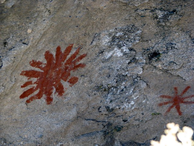
Along the way, there is a Tataviam Indian archaeological site. There is a flat rock that they used for a grinding bowl plus there are some pictographs on the rock behind the grinding bowl. One of the docents told me that these are exact replicas and that the original pictographs are in a section of the park that is closed to the public so they will not be destroyed. The originals have been there since 450 AD.


Below are photos of the grinding bowl and the replica pictographs. The large flat rock that you see in front of the tall rock in the background is the grinding bowl. There were little indentations in this rock where they Indians had ground their seeds and other things into a dry paste.


Here are the replications of the original pictographs that are protected in another area of the park.


Below you see the pictograph of a rattlesnake


The next photo is of "The Witch's Hat" rock. We were told by another docent that you had to stand in a particular place to actually see the "hat". He was correct, because if we stood in other areas, it just looked like an ordinary rock.


Next you see a close up of the "brim" of the hat. As you can see, it is not even connected to the rock that juts up making the point of "the hat". In fact it looked like a flat rock that had broken off from somewhere and landed on these other rocks. Jean and I thought it looked more like a UFO up close.


All in all, we had a great morning where we learned some history and also had some good exercise.

Saturday, May 4, 2013

Previoiusly Unexplored Areas Of Vasquez Rocks

My brother Keith was visiting last week and one morning he and I decided to pack my dog Hiker into the car and we headed up to Vasquez Rocks. This is one of Keith's favorite areas to explore and I love photographing the area. We have hiked there so many times that we decided to head off in a direction that we had never taken. We found ourselves on the Pacific Crest Trail.


As we followed the trail, it took us along a ridge in the south eastern part of the park. From this vantage point, we saw beautiful view of the rocks and the surrounding area.


From the ridge, we could also see the trail twist and turn down into the canyon and then start back up over the other side.


The panoramic views were spectacular.


Keith took this shot of me and Hiker with the mail rock in the background.

Wednesday, January 30, 2013

A Morning Hike In Pico Canyon

I love Pico Canyon. It has so much history. The old oil town of Mentryville, CA is there and there is old oil machinery and a historical sight there. Hiker and I took our neighbor Jean on a 5 mile hike there today. She had never been there before.

You park in the lot next to what is left of Mentryville and head up the canyon on a paved fire road. There is a pretty little side trail that goes up into a little canyon with a small creek, a lot of greenery and an oak grove. When we have a good wildflower season, this little canyon is full of blue lupines.


We then headed back to the main trail and headed farther up into Pico Canyon. At one point there is a spot where the old oil workers had an outdoor "casino". There are still card tables there and a frame for a roulette table. There is also an old wooden oil derrick there.


We continued on and came upon some old oil machinery the reached the historic sight of the first commercial oil well in the state of California. It is marked by a couple of plaques that tell the history of the well.


Here you can see the capped off well.


We went a little farther past the sight because I wanted to show Jean the Santa Susana Thrust Zone. Then we headed back down to the car and headed home.


In the photo below, you can see the twisted rock of the earthquake fault in the thrust zone.

Monday, January 28, 2013

A Bit Chilly, But Still A Great Hike

It was so beautiful outside this afternoon. I put Hiker in the car and we headed over to Placerita Nature Center. Even it was a little chilly outside it was warm in the sunny areas.


We headed across the parking lot and through the field, then walked through the Oak Grove picnic area and headed for the Canyon Trail.


As we entered the canyon, it became much colder as the sun could not reach down into the bottom.


When we got to the 1 mile marker along the trail, we stopped to rest for a few minutes and enjoy the view.


Headed back down the trail and back to the parking lot. A nice 2.7 mile hike.