Friday, January 27, 2012

Bison Road Trail In Hart Park - Newhall, CA

My friend Linda emailed me the other day and said she had read about a walking/hiking club that meets up every Friday at William S. Hart Park in Newhall, CA. She wanted to check them out, so I packed up Hiker and we picked up Linda then headed over to the park. It was cloudy and starting to get windy. The group meets up was supposed to be at 9:00 am but most of the people did not show up until between 9:15 and 9:30. There were about 10 to 12 people (mostly seniors). They then proceeded to do warm-up stretches. Hiker was going crazy wanting to get going out on the hike. We all finally headed out for the Bison Road Trail which runs through the hills behind Hart Park.


Everyone started out in a group. The leader and a few other's took off ahead of everyone. Linda and I bought up the rear as we had no idea where the trail was. There was another woman who stayed back with us and we introduced ourselves and started to get acquainted. Before we realized it, most of the group had gotten way ahead of us. The trail began to climb and a steep incline and Linda, Hiker and I fell further back from the pack.


Linda began to get very winded, so I lagged back to stay with her and by now the rest of the group was at least a quarter of a mile ahead of us. Every now and then they would see us from a higher level of the trail and yell to ask us if we were OK. We told them to keep going and that we'd follow. I guess their thing is to walk fast and do the hike as quickly as possible, where as Linda and I prefer to take our time, stop and take photographs and enjoy the views, and there were some really nice views from this trail.


Hiker seemed to enjoy the hike as she always does.


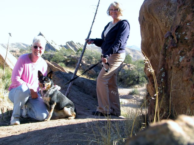
Linda took this photo of me and Hiker up on the ridge.


We climbed and climbed and climbed, not knowing where the rest of the group was. Finally we reached the summit and then headed down into a private campground that is used by the Boy Scouts and Girl Scouts.


After about an hour and 15 minutes and 2.5 miles, we finally made it back to the parking lot where most of the group had already left, but there were still 3 people there waiting to make certain that we made it back to my 4Runner OK.

Actually it was a pretty nice hike (if you take your time to enjoy it) and I would enjoy doing it again sometime.

Directions to the Bison Road Trail.

From the Hart Park parking lot, walk out to the street (Newhall Avenue) and take a left. Walk to Market Street and take another left. Continue to the parking lot behind the Santa Clarita Senior Center. Enter the parking lot and walk all the way to the back of it where there is an opening in the chain link fence to your right. Follow the dirt trail (fire road) as it winds up the mountain.

Sunday, January 15, 2012

Photo-Op Hike At Vasquez Rocks County Park

After having lunch at the Sweetwater Cafe in Agua Dulce, CA, my friend Linda and I decided to head over to Vasquez Rocks County Park which was only a couple of miles away for a "photo-op hike". My dog Hiker was with us and she loves Vasquez Rocks.

Here is a satellite view of the park.


We decided to hike some trails that we had never photographed before. The weather was clear and beautiful and the sky was dark blue. Hiker was busy exploring everything around her.


This area of the park looks like a "miniature" version of the main area of the park.


There are holes in the rocks like this all over the park. They are caused by the the wind and the rain, plus I'm sure that little animals also dig and burrow into the soft sandstone to create their dens.


Linda inspects the holes after making sure that there was nothing living inside of them.


Here we are....Me, Hiker and Linda.


Looking south toward the main area of the park.


The "big rock" from a different angle.


Directions to Vasquez Rocks County Park:

Vasquez Rocks Natural Area Park is located near Agua Dulce Springs north of 14 -Palmdale freeway. The park is about midway between Santa Clarita and Palmdale.
Address: 10700 W. Escondido Canyon Road, Agua Dulce
Phone: (661) 268-0840

Changed Blog Title

Decided to change the title of this blog from "Hiking With An 'Old' Woman" to "Take A Hike!"

I just didn't like the old title anymore because I don't feel like a 'Old' woman and I think you are never too old to enjoy nature.

Thursday, January 5, 2012

Hiking The Devil's Punchbowl Loop Trail - Pearblossom, CA


Today, my friend Linda and I took Hiker out to Pearblossom, CA to the Devil's Punchbowl Natural Area. Ben and I went to this sight back in November 2009 and I have always wanted to go back and hike the trail down into the "bowl". Ben was not a hiker, so he didn't want to go down the trail when he and I were there. The trail is about a mile long, but takes about an hour or more depending on how fast you walk and how often you stop along the way. It descends 300 ft. into the "bowl" and takes you all the way to the bottom where there is a year-round creek. But then...you have to climb back up out of the "bowl". This area is part of the San Andreas Fault line so these rocks are "thrust faults" coming up out of the ground from pressure put on them by two plates of the Earth's crust pushing into each other.


You can start your hike at either end of the loop. We chose to start near the Visitor's Center on the North side of the "bowl". There are many great spots for photo ops along the trail. Sometimes you lose track of the trail, even though it is marked all along the way, because people have gotten lazy and do not want to take all of the "switch backs" so they take short cuts and create new sections of trail which makes it confusing at times.


I would advise you take this hike in the fall, winter or spring as it would get pretty hot there in the summer.


Here is a link to the Devil's Punchbowl Website if you'd like to check it out:

http://www.devils-punchbowl.com/